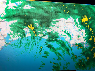
NHC's future track brings Nicholas into western Louisiana at a crawl only reaching Alexandria by Friday. That keeps the heavy rain potential high all along the Gulf coast from LA. to FL.
I'm not sure another 6-10" is realistic since the main rain bands around Nicholas have been blown (decoupled) to the east away from the surface center.
You can see in the bottom photo all the brighter cloud tops way away from the center (arrow) that is still in Texas. Radar confirms a drying trend is coming for most of us that may last for many hours.
It has hardly rained in Houston all day despite being so close to the center. That drying trend is getting close to NOLA.
Notice what the clouds & all day rains have done to temperatures. It's a rare day in mid September when we stay below 80. Unless some storms form around Nicholas, I'm hoping models are overplaying our rain threat the next couple of days?
There is a cold front to our north, but it has no support to push it much farther to the south. Note the 40 &50s dew points have moved over the northern plains where the air feels great. We're stuck in the muggies for the rest of this week.
Finally, NHC is following two areas that might have tropical potential. Fortunately neither will be our problem.


1 comment:
Well we've had our Labor Day storm for 2021 and it was a doozy. Up here in Hammond we were hammered. Being knowledgeable about weather yes we evacuated. Thanks Bob for all you do you're pretty much my go to guy for storm info, I guess you could say that you are the modern day Nash.
Post a Comment