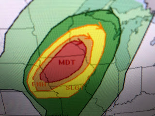
Once again they have a level 4 risk that includes much of Iowa and extends into Minnesota. There has NEVER been a EF 3+ tornado in Minnesota in December, but SPC has them on alert. The bottom graphic has all the areas under a high wind warning along with the severe (yellows & reds) risk.
A fast moving upper disturbance in northern Kansas is producing a squall line with high winds & lots of lightning. On the east side, very warm air is making it feel like Spring while on the backside (western) it's Winter. Let's pray that it doesn't happen again like last Friday. So what the heck is going on?
There is an East Coast trough along the East coast, but it doesn't extend down into the South. You can see the cold air clouds over the Gulf Stream with temps in the 30s & 40s. That part of the nation has been seeing basic "normal" December weather.
The rest of us have not as the main storm track has soaked the NW and is now finally bringing much needed rains to California. For us over the South and SE, it's been way too warm and mostly dry. Note the temperature contrast from 25 at Rapid City, S.D. to 71 at Omaha. No wonder there's the potential for severe weather!
We'll stay in the warm air sector for the next 3 days before a cold front arrives on Sunday. There is a surge of high dew points (low level moisture) from the Gulf all the way up to Wisconsin.
Over night lows may stay above our average/normal highs (65) with the main concern how dense the morning fog will be? The Sunday cold front will stall along the northern Gulf keeping clouds and lingering shower around into Monday. Now the question is...will it remain cold through Christmas weekend? RIGHT NOW, I don't see that happening as Christmas Day looks mild (65-70+) with no snow! Sorry Gang. Stay tuned!~


No comments:
Post a Comment