The next named storm (Nicole) probably will be the swirl way out in the Atlantic while the system expected to develop over the Bahamas is not there yet. However, look at the bottom graphic valid for late next Wednesday. Sure looks like a named storm to me.
It's getting really cold (15-29 below) over Alaska & Canada, but the upper flow that had dipped over the West is beginning to flatten out for this week. That will keep us warm/above normal for most of next week with our next real cold front arriving for next weekend. Note the SW upper flow along the East coast that has them warmer than us!
The cooler and drier air to our west has come to a halt and we'll stay summer like into next week.
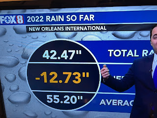
Today's rainfall generally was 1-2" of much needed moisture. Zack showed us this morning how dry we've been.
MSY recorded 1.44" while I had 1.37" in Metairie. I don't think we'll see another widespread rain opportunity until next Friday when a strong front approaches. I know my yard and plants enjoyed today's soaker. For tonight, let's Roll the Tide! LSU 38 Alabama 34 Stay tuned!


No comments:
Post a Comment