Zack pointed out on his morning programs the record breaking potential & Nicondra confirmed that our high has been at least 80. More newsworthy is our overnight low stopped at 65, or 3 degrees higher than our normal high. We'll stay very mild overnight so tomorrow's lows will again be warmer than a typical January high. But a big change is coming.
A dip in the jet stream (upper low) is digging towards the Southeast. That will crush the upper ridge that has kept us so warm and while bringing down typical January cold now over the northern Plains. Although this is not the Arctic Blast like last month, it appears the North Shore will be in for a light freeze this weekend with the coldest mornings being Saturday & Sunday.
Such a sharp temperature drop, coupled with brisk northerly winds will require the heavy weather gear if you plan on being outside this weekend. The good news is the sun will be out. In the short term, a cold front will trigger some showers/T-Storms with the main severe weather risk well to our north & east.
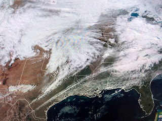
the satellite view shows the limited Gulf return flow with surface dew points in the 60s instead of 70+.
The cold front won't arrive until midday so the morning hours will be warm. Don't leave home without a sweater or jacket tomorrow. here's the timing.


No comments:
Post a Comment