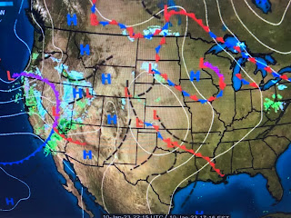
As the upper trough deepens, it will drag a cold front through us by Thursday PM. SPC has us in a slight risk for severe storms, but the greater threat appears well north and east of us.
Hannah Gard showed us the computer model timing of the rain that clearly has the heavier storms well north of the Lake. It appears to me the upper dynamics and well north of us and the fast motion of the cold front will limit rain totals to less than an inch at most.
In the short term, the satellite view doesn't show deep Gulf moisture while the surface map doesn't yet have the cold front. We already are in the warm sector with 80s across Texas. The cold air up north isn't as frigid as that Arctic blast back last month.
So we will see a brief cool down for this weekend, it doesn't last long as we soar back to 70+ for next week. There are signs that point to much colder air coming for the last 10 days of January. Finally...
More rain is coming to California. Most of the state has received double their rainy season normal and I suspect the new drought monitor (out on Thursday) will have reduced the areas in extreme (red) drought by a lot. Stay tuned!


No comments:
Post a Comment