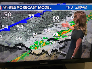
Since tomorrow's record is 80, we have the opportunity to make it back to back record breakers. What's the reason for the warmth? Basically it's the lack of an East Coast upper trough.
For most of this Winter, the upper trough has been over the West coast & Rockies as "atmospheric rivers (9)" have battered California bringing much needed rain & snows to the western states. That will change a little later this week, but I don't see any real Arctic chill coming for the rest of this month.
It is seasonally cold across the northern tier of states with the exception being the South and into the Northeast.
We have one more day of near record warmth before a cool down arrives on Thursday. Note the dew points has surged into the 60s telling me deeper low level Gulf moisture will increase the sea fog chances and give parts of Louisiana a slight threat for severe storms Wednesday night after midnight.
The cold front will clear us for Thursday but the clouds and rain move back for the weekend along with colder air. You'll need sweaters and jackets/coats again.
Finally, while I was out fishing yesterday, NHC identified an area of low pressure off the East coast as Invest 90 L. It appeared to have T-Storms rotating around a well defined low level circulation. Why was it not given a name? Don't know.
Now compare that to the bottom satellite view of Tropical Storm Colin last summer. At the time I called it a wasted name, which is was as it quickly dissipated over the Carolinas. Look at those photos. Which one looks more like a tropical system? Go figure. Oh, after catching our limits 2 straight days 2 weeks ago. Captain Hylton and I went back to the same spot and we caught 4 fish. Go figure that too. Stay tuned!


No comments:
Post a Comment