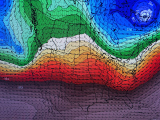
I drew the upper flow on the satellite view that shows why the real cold up north can't come south. However, look at these upper air forecast charts.
The top chart was valid this morning showing a mainly west to east flow. The 2nd graphic is valid for Thursday already indicating a deepening trough over the Great Lakes. The next is valid for Friday than clearly has the flow coming straight our of Canada. The bottom view is valid for next Sunday with the trough lifting out and milder air quickly returning. Back in December, the Arctic blast had temperatures up in Canada 40-45 below zero. Not so with this one as many parts of western Canada have temps above freezing.
As the center of the surface high moves to the east, southern winds will bring back low level moisture/higher dew points in the short term. Here's the timing on the next front.
We'll drop from highs in the 70s to highs in the 50s with nights in the 30s & 40s. Since we are in the coldest 2 weeks of the year, historically, this next front will just get us back closer to our long term daily highs & lows.
Parts of the North Shore might get near freezing on Saturday & Sunday, but not those of us south of Lake P. Finally...
The wet onslaught into California continues causing many issues from fallen trees, power outages, mud slides & street flooding. Note the bottom graphic is the drought monitor from last week that still has much of California in exceptional drought. The new monitor comes out this Thursday and should show less drought. Another 2-3 storms are predicted before the pattern shifts late next week. Stay tuned!


No comments:
Post a Comment