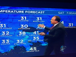
As a precaution, I brought some of my potted plants back into my He-shed even though my gut tells me those winds coming across the Lake will keep temps 35-40 on the South Shore. This is not a night we need to run the water unless you live well north of Lake P.
Satellite views confirm the cold front has pushed down into the southern Gulf as you can see the cold air clouds aligning themselves with the northerly wind flow. The upper low already is over the Carolinas and it will lift away during the day on Saturday. The ridge to our west will bring back the warmer air for Sunday into next week.
So the next 2 nights will have near freezing temps. before we soar back into the 70s next week. In the short term, this weekend looks terrific with sunshine and seasonal January temperatures.
This cold spell is no where close to the Arctic Blast of last month. The core of the cold will stay north & east of us as you can already see the warming happening over Texas. Dew points are very low making the air feel great, if you're dressed for it.
Today ended a 15 day stretch of above normal/average temperatures. The bottom graphic shows our lowest/coldest temperatures happen during the 3 week period in January as we slowly warm heading into late February. We are not done with more cold air/freeze threats. Hate to see us this mild/warm before the Mardi Gras parades. Enjoy your weekend & stay tuned!


No comments:
Post a Comment