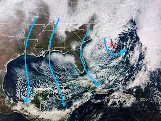
Hannah showed us this morning how we finally ended our 15 day stretch of above normal temps. I love to use satellite pictures to explain our weather.
A surface low has formed off the Carolina coast and that is enhancing the surge of cold air down across the Gulf into Cuba and through the Yucatan. All of Florida, despite sunshine is chilly with Miami barely into the 60s & Orlando in the high 40s.
Some high, thin clouds are spreading back up over the surface ridge, but from the Rockies to the East Coast it's mainly dry. You can see the warmer air surging around the backside of the surface high.
All the wet weather is along the West Coast as the "atmospheric river" keeps recharging itself. Although all the storms have created damage & inconvenience, much needed moisture has put a huge dent in their many years drought. And it's not just California but the mountains of Utah & Colorado that have received many feet of snow. The energy from the current California system will stay well to our north this week.
Not sure about the late week front making it through us. Our best opportunity for widespread rain appears to hold off until next weekend.


No comments:
Post a Comment