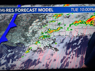
Since I'm going fishing later this morning, I'm doing an early post. The thinking hasn't changed since my last post as the upper storm that battered California on Saturday has moved into the Rockies today and will trigger a widespread severe weather outbreak across the South during the next two day. We have no threat today as the bullseye is to our west & north. That shifts over us for Tuesday.
Zack Fradella pointed out when the storm is this morning.
The top graphic is the SPC's severe risk for today with the next two shifting the risk over us on Tuesday. Note SPC has increased that risk for us to a level 3 (enhanced) and has a hatched area (higher risk) for us northward. Tomorrow will be our pay attention day. Zack timed out when storms are most likely.
So make sure your FOX 8 weather app is reafy to let you know if/when warnings come out tomorrow PM.
Once this system flies by, Wednesday & the rest of the week look dry with a gradual cooldown. For early January, sunshine and 60-65 is pretty good compared to the rest of the nation. Stay tuned!


No comments:
Post a Comment