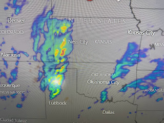
The top graphic is the satellite view with the Upper storm coming out of the Rockies. The next is this morning's upper air (500 mb) flow with the bottom graphic the upper flow valid for March 14th. Note the big difference. The bottom has the "Polar Vortex" over the Great Lakes allowing the Arctic air to plunge into the eastern states. That's the long term pattern shift. Let's deal with this week.
For tonight, SPC has a high (level 4) severe risk as the California system from Friday heads eastward. Note the tongue of warm air (70+) surging into west Kansas. It could be a rough night after dark for OK/KS/TX.
For us, we stay in the warm air for most of this week. The first system will bring a front close, but we'll have to wait until the end of the week for cooler temperatures.
The middle view shows the sharp snow cover line across Wisconsin into Michigan. The bottom view is the snow cover (yellow arrows) over the southern California mountains north of LAX. I loved to use satellite view to point out features, to educate my viewers & to sometimes entertain. It's a lost art as all the local weathercasters just show computer model hour by hour, computer model forecasts, water vapor etc. but don't you all just want to know..."Yeah, but what does ??? think?" Nobody wants to challenge the computer. Rather be wrong with everyone else than the only one right. Stay tuned!


No comments:
Post a Comment