For the next 3 days, the center of the upper high builds eastward over the Gulf allowing for several disturbances to drop into Louisiana. However, the bottom graphic for Saturday shows the heat bubble surging to the north towards us. What does that mean? The extreme heat (95-100) will be delayed here until Friday. With the upper high building over us for this weekend, it will limit our rain chances to near zero allowing for temperatures to flirt with 100. Yikes!
So what the heck is going on? Let's begin with the upper air flow that is keeping much of the country cooler than average.
Note that stalled frontal boundary across the South. That will be the area that sees higher rain chances with the potential for severe storms.
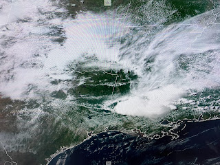
It appears this current batch of storms will stay well north of Lake P., but we could get in on the tail end with some showers arriving near dark. The cloud cover didn't arrive soon enough as temps have been in the low to mid 90s. But more storms are coming.
Another cluster of storms is firing back north of Dallas heading towards the SE. This Ring of Fire pattern should last into Thursday with most of the rain remaining north of us. We really could use a good soaker now that highs top 90 every day. It doesn't take long to dry out. Finally,
There is nothing happening in the Caribbean or Gulf. The GFS continues trying to develop something, but we all know beyond 7 days, models are usually not accurate. Stay tuned & pay attention to those storms moving north of Lake P. this evening.


No comments:
Post a Comment