There is an old frontal boundary draped across southern Arkansas & northern Louisiana, but it has run out of upper support and will stall before reaching us. I expect that deeper Gulf moisture combined with daytime heating will finally give us rain coverage more typical of our Summer days (40-50%).
Remember, 60% rain chance has NOTHING to do with time. It means 60% of our local area will receive some rain. There will be many dry hours between showers. Today's coverage so far has been 20-30%.
With temps 90-95, we still have time to bubble up a late storm.
The Southeast & eastern states remain in very humid/soupy air while the real heat has centered itself back over the desert SW. Hopefully, we seen several rainy days before that big heat dome returns here for next week.
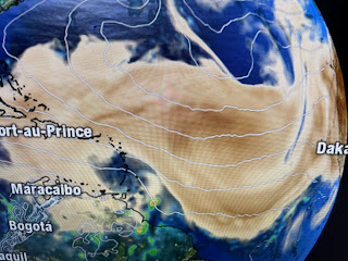
There are several waves moving to the west over the Caribbean & coming off of African. But look at how the Saharan Air Layer (SAL-Dust) has stabilized the Tropical Atlantic. Even the Pacific has gone quiet for now. In fact, I looked globally & could not find a named storm. Let's enjoy our holiday celebrating our FREEDOM & remember all the active duty military families that allow us to enjoy life. Peace. Stay tuned!


No comments:
Post a Comment