The IR (color) loop shows no storms around the center of circulation, hence NHC seems to believe nothing will form since no model indicates that. So where will that moisture go?
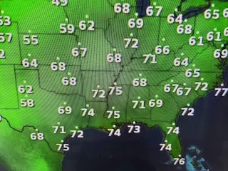
On the top view I drew in the axis of the Atlantic ridge/Bermuda High that has steered the deep moisture towards the Texas coast. But that moisture is likely to rotate around the ridge right over us the next two days making for above normal/average rain chances. If you're looking for cooler air, you have to head to the northern plains ore Rockies. it's not coming our way until October!
What a difference a week makes. Last week we saw few clouds and no rain. Look at today. Can you tell who's seeing the rain? I had .42" yesterday and another .93" today. That's more rain than I had in the 30 days of June!
So my guess is we'll see even higher rain coverage Thursday & Friday before drying out a little for the weekend. Today I got a haircut, but so did my yard.
As we head towards the heart (August/September) of hurricane season, I had my friends at Abita Tree Service come give my 60 foot oaks a thinning along with my smaller crepe myrtle. By thinning the canopy, IF we get a hurricane, there will be less resistance from the leaves keeping the trees upright. Yes, it costs some, but if you compare it to your hurricane deductible IF the tree fell onto your house, it's far cheaper & you don't have to deal with your insurance company. Click on the link below to find Abita Tree Service.
https://issuu.com/in_magazine/docs/storm_guide_2023-fullbook
We have some time to prepare, but don't wait until August. Stay tuned!


No comments:
Post a Comment