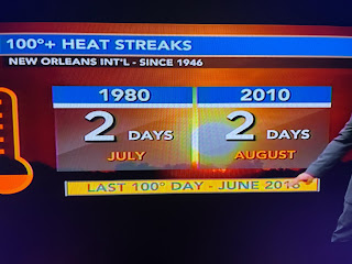
Ch. 8 has come up with some good looking graphics trying to hold your interest when nothing seems to be changing.
Nicondra showed today's high reached 100 so we now have the first time we've topped 100 for 3 straight day. I don't want to depress you, but look at the rest of this week.
As Zack showed us this morning, last week was our hottest week ever at MSY going back to 1946.
On the bottom graphic, you can change the lower numbers to 10, 5 & 3 with today's 100 degree high. So what is going on?
No the whole country is not on fire, only the southern 10 states. The upper heat dome is shrinking, but it is not going away.
So until that breaks down, look for triple digit highs into the weekend.
A couple of stray showers have popped up, but the bulk of the rain remains far to our north & east.
Gosh, the rain is so close yet so far. 70s 7 80s to our north while we bake in 95-100+.
The good news is the Tropics are staying quiet. No model develops anything for the next 7-10 days. All the action is in the Pacific south of Hawaii.
Hurricane Dora has weakened down to 130 MPH, still a strong Cat. 3. It is passing well south of the big Island and is no threat. For us it's hard to talk about anything else except the heat. Typically, we start seeing cold fronts by mid September (5 weeks away) with REAL cold fronts by October 1st. So we are in the tunnel Gang, and the light ahead is October! Stay tuned!


No comments:
Post a Comment