It is predicted to stay well south of the big island. As we approach mid-August, we know what typically happens in the Atlantic & Caribbean. When will the switch turn on? So far, nothing.
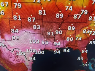
The current conditions have the blocking surface Bermuda High/Atlantic Ridge centered NOT over Bermuda, but closer to the Azores. With that set up, anything coming off of Africa would likely turn around the ridge to the north well east of the U.S. Right now, we continue with the blocking upper heat dome that is baking all of the southern states.
That upper pattern doesn't look to be changing so expect another week of this brutal heat.
I promised not to whine about the heat every day, but let me remind you these temperatures are dangerous, especially to the "elderly". My neighbor (Bernard) chopped down a small dead tree in his yard yesterday while this little fella was out power washing my driveway. We both are in our mid 70s and stayed hydrated. However, being out in that hot sun takes a toll. Both of us felt "sick" last night & today. In fact, I took a nap this afternoon and I NEVER take a nap. My suggestion is to stay out of the Sun between noon & 4 PM.
We do have lots of clouds and storms to our north and east, but they're not moving our way. Without rain, we're way too hot. I'm a little suspicious regarding the 100+ at MSY. Note the wind direction is off the 90 degree waters of Lake P. My home gage was reading 96 at the same time. New airport buildings & tarmac? Whatever, either reading is too hot. Stay tuned!


No comments:
Post a Comment