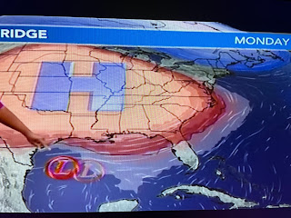
Such could be the case with our current Gulf Disturbance that will be named Harold tonight.
Harold cannot turn to the north due to the lingering blocking upper heat dome, so south Texas will be the lucky ones to be drenched with 2-4" of needed rainfall.
TD 9 is kicking some high waves offshore & rough coastal waters, but those brisk east winds have brought less hot air in from the Gulf.
You can see the difference between the North Shore (95-100+) and the South Shore (87-92) due to increase clouds and some spotty showers. But don't get use to it as that upper heat dome is coming back for the rest of this week.
Almost every day will set new record highs, but Nicondra did have that upper high backing to the west for next weekend. That should result in higher rain chances and less hot temps.
The rest of the Tropics remain active, but Emily & Gert are gone while Tropical Storm Franklin is struggling with the upper wind shear that might keep him from becoming a hurricane. Hannah Gard had a graphic that well why it's more than just warm ocean water.
In an El Nino summer, the upper wind shear is our friend. Add in the heat dome and we'll remain protected for the next 7 days. What we want is for the MJO to go back into an unfavorable (sinking air) phase for September and then have a bunch of early season cold fronts for October. Stay tuned!


No comments:
Post a Comment