Harold is not a drought buster ore heat breaker, but he has brought temporary cooling that won't last.
The only other tropical feature of note is Tropical Storm Franklin struggling to reorganize south of Hispaniola. There is a swirl of low level clouds exposed west of the main T-Storms (yellow arrow) with a new center (orange arrow) trying to form farther to the east. NHC and models slowly move Franklin to the NNE without becoming a hurricane until he pulls well away from the Island over the weekend.
For us, I see no tropical threats as we head into September. We just have to keep dealing with that stubborn upper Heat Dome.
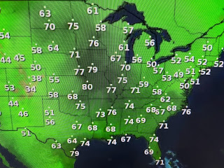
What is making this summer heat feel worse is the high dew points (75-80) that have surged into North Dakota & Minnesota. To see 80 degree dew points in Kansas City is pretty unusual.
So until we have something to change the stalled upper air pattern, our lingering record breaking summer heat wave will continue.
About the only hope we have is to see a stray isolated daytime heating shower pop up.
Everyone is calling for 100+ the next 5 days, but I think what might limit temps. is the wind direction. During our last stretch of 100+, surface winds were WSW. IF winds stay out of the ESE, that should keep the South Shore less hot. Will you notice the difference? Nah. Hannah Gard had some graphics that pretty much told us what we already know. It's been a long, brutally hot (more so than "normal") Summer.
I could whine on, but no, it's happy hour & I'm heading to chardonnay country! Stayed tuned!


No comments:
Post a Comment