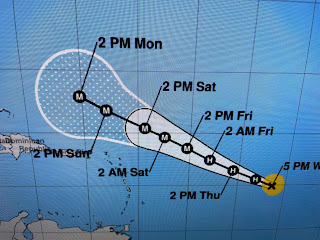
The latest NHC centerline track has slightly shifted to the right (north) now keeping Puerto Rio & the Virgin Islands outside of the cone of error.
In the NHC discussion, they indicate the steering for Lee will weaken as he flirts with the northern Bahamas. An upper trough predicted to come down over the Eastern U.S. should turn Lee to the north & then east, but will this happen soon enough to keep him away from the Northeast Coast? It's gonna be a close call.
You can see what that dip out of Canada is doing with temperatures. The 30s, 40s & 50s over Canada are heading southward.
The cooler air will not blow through us as a giant front. Rather, it will come down is subtle waves or boundaries. In the short term, we'll stay hot, but I'm more optimistic than the FOX 8 seven day on cooler temps next week.
As a weak boundary heads south tomorrow, it should increase our PM rain chances.
I think we all agree, enough of the 90s! We want Fall! Stay tuned!


No comments:
Post a Comment