Nigel is way off the East coast and his track will keep him only a problem to shipping. The satellite presentation has yet to show the donut hole eye, but that is likely later tonight and tomorrow. The other two areas are indicated by computer models developing into our next two named storms.
The system coming off of Africa does have a well defined swirl (arrow) but no storms with it yet.
The other potential area off the Carolinas has no clouds there yet. But models suggest something will form as we get to this weekend. Since it's east of Florida, it will not be our problem. Our problem is the lingering summer heat.
We do have an upper low over the Great Lakes with a trough down over the SE. That's where the chilly air is and has been for much of this Summer. But under the upper ridge, temps are near 90 all the way to North Dakota.
Less we be greedy, we're grateful that the front that did sneak down into the Gulf has brought us much lower dew points (40s & 50s) that will allow cooler morning temps.
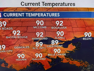
But with few clouds and no showers around, we remain way above normal/average.


No comments:
Post a Comment