The time line begins before noon (top view) to Cat. 1 at 2 PM followed by Cat. 3 by 7 PM and Cat. 5 before midnight. the bottom view has the track that was well behaved with no loops or curves. Otis is an emergency manager's worst nightmare, rapidly intensifying allowing little time for evacuation. Fortunately, our season stayed quiet here. Now it's on to Winter-like storms.
The dip in the jet stream is over the West with a blocking upper ridge over the east & south. The season's first snow storms is developing across Montana. All of Canada has gotten chilly, so it's just a matter of time before the chill reaches us.
Where the cooler air is colliding with the lingering warmth across the Southeast, some welcomed rains are falling.
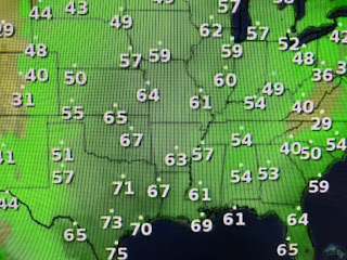
Unfortunately, the rains are not coming our way heading northward around the blocking East Coast high pressure. Note the surge in low level moisture (dew points 60+) surging all the way into Wisconsin. In the short term, we stay summer like until the front arrives on Monday.


No comments:
Post a Comment