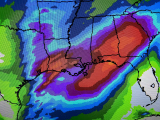
You can see SW Louisiana is in the level 3 risk tomorrow, but SPC lowers that risk over us to level 1 (marginal) for Friday. There are several limiting factors for development with the biggest being the weakening upper energy coming from the California low.
Yesterday the low was well defined with lots of clouds and showers west of San Francisco. Today it's west of Los Angeles with fewer clouds and only a couple of showers. The other critical factor is the lack of low level moisture as dry air lingers along the norther Gulf coast.
I've drawn the frontal boundary over the satellite view showing south Texas is near 70, but dew points only in the 40s & 50s with 30s over us. Over time, our dew points will rise, but by then the upper energy(western low) that triggers storms will have raced way to our north. Bottom line, most of Thursday will be dry here with some moderate to heavy showers Thursday night lingering into Sunday.
Nicondra showed the model timing at 4 PM with the bottom graphic from the WPC (Weather Prediction Center) that has one bullseye over SW Louisiana and along east of Mobile. My gut tells me we'll see 1-3" of rain spread over 3-4 days with the heaviest being over the North Shore. So don't let all the hype get to you. I see no reason to be more anxious just because some rainfall is coming. We need it.
As the upper low lifts to the north by Saturday, that stubborn SW upper flow will stall the front near us, so don't expect much sunshine as we head through this weekend. That also means no real cold air will return either.
Our next shot at real cold air arrives NEXT Wednesday. We started below freezing on the North Shore with near freezing away from the Lake south. Everybody recovered into the 60s this afternoon.
As winds turn back off the Gulf tonight and tomorrow, much milder air will be around in the morning continuing through the weekend. So expect periods of rain arriving late Thursday lingering off & on into Sunday. Should be no big deal from what I'm seeing now. We'll give it another look tomorrow. Stay tuned!


No comments:
Post a Comment