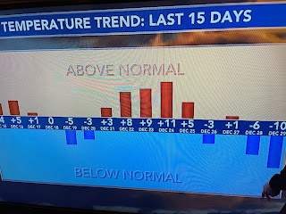
You can clearly see in the temperature trend for the past 2 weeks the cycle the weather takes between up & down. We're about to go briefly up before we cool down for next week.
Even though there is a general upper East Coast trough, there is no super cold air (40-50+ below) except over Russia & Siberia. Hints of a "Polar Vortex" showing up next week have vanished as a series of Pacific storms plow into the West Coast and then head our way.
After our 7th wettest December at MSY, it looks like 2024 will continue that pattern that will totally eliminate the drought from the past summer. In the short term, our Sunday looks to begin sunny as there are no signs of Gulf return flow.
You can see the dryness in the dew points in the 20s & 30s. As a weak front blows through early on Monday, there might be a couple of brief showers, but that's well after midnight so the fireworks should have no issues.
Tomorrow will be the nicest day for awhile as next weeks looks nasty. Finally, looking over my garden as we head towards January, can you see what I found? Not in the first pic, nor the second, but...somehow I heard Bette Midler singing.
"Just remember in the Winter far beneath the bitter snows (OK, so we have no snow!), lies the seed that with the sun's love in the Spring becomes The Rose". Some say the rose means love. I felt it! Enjoy the weekend, stay safe & stay tuned!


No comments:
Post a Comment