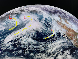
It took the 7th wettest December to put a dent into our exceptional drought conditions. And more rain is coming as we head into January. Mardi Gras is still weeks away, but the parade of storms off the West Coast goes all the way back to Japan.
These storm systems will ride the southern jet stream right across the country so get ready for more heavier rainfall next mid week and into the weekend. In the short term,
A weak cold front will push through by Monday morning with few, if any showers. See how low the dew points are (30s & 40s) indicating limited low level moisture. The system mid week looks stronger with next weekend's disturbance even stronger.
I mentioned the possibility of a southern snowstorm, but the lack of cold air will limit any snow to Kansas, Missouri & Illinois. Long range, there are no signs of an Arctic outbreak coming into the Gulf South through mid January. We'll see several rainy periods with brief cool downs & warm ups in between.
After another frosty start, we warmed to near 70 with bright sunshine. Clouds will move in over night keeping us much warmer before the cold front arrives Monday morning.
Tonight's fireworks should have no issues as skies are clear & winds light. 40% is probably generous for tomorrow's rain coverage. The real rain chances arrive with the two systems that follow. So let's welcome in the New Year, hoping everyone stays safe. Ch. 8 has agreed to have me back for another hurricane season in 2024 so this blog will continue, God willing & you keep watching. Stay tuned!


No comments:
Post a Comment