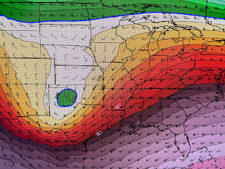
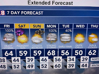
There is a well defined upper low over New Mexico with the split between the northern & southern jet streams happening over east TX/OK/LA where moisture is limited. A slight warm air surge is from Houston to Brownsville with all the rainfall well west of Dallas.
By dark on Friday, the surface low is very near us, but it appears we never get into the warm air sector. Here are the predicted rain totals. Most of us are in the 1" or less areas with the really heavy stuff staying well off the mouth of the River. SPC's severe risk is a level one (lowest) all along the coastal locations.
Now, compare Monday's system where we do get into the warm air sector.
That will result in much higher severe threats and we're likely to be under Tornado Watches & warnings. Why not for Friday? Good question. Let's compare the upper air maps.
The disturbance/low in New Mexico today lifts into Kansas during the day on Friday and into Wisconsin by Saturday. That's why I don't think Friday's system will be much more than a brief period of moderate to heavy showers. However, now look at Monday's forecast upper air system.
It's develops over New Mexico and heads into southern OK & AK and then into Tennessee. That brings the upper energy much closer to us plus the system appears much deeper. Bottom line, know some rain is coming for Friday afternoon and evening, but I'm not expecting any widespread problems. We'll need to pay much more attention on Monday when highs could jump into the 70s ahead of the cold front.
More cold air follows for next week, but I want to sound the alert for a possible "Polar Vortex" during the next 2 weeks. Super cold (40-50 below) air is finally showing up in Canada and the upper air forecast for Jan. 16th has that Polar Vortex over the Great Lakes. That would bring a hard freeze threat down to the Gulf coast.
This is not rocket science Gang. Unfortunately, most local weathercasters are forced to stay local (by station consultants)and not explain the why of what's coming. I don't have those restrictions. Stay tuned!


No comments:
Post a Comment