The upper low west of Washington is NOT coming our way. I've drawn (yellow dash) the spokes of energy rotating around the main low. Here's what the GFS computer model does with that low. The top view is the current upper air flow at 18,000'.
The second view is for Friday, followed by Saturday Sunday & Monday mornings. Clearly, the main upper low stays off the West coast with a new low forming on Friday over Colorado. You can follow that energy/low diving down across Louisiana and that will bring clouds & showers our way. What I'm seeing is the POSSIBILITY that the heaviest storms remain south of the Louisiana coast, but it's certain we will have rainy periods beginning Saturday PM. Here's the model timing beginning with daybreak on Saturday. Showers are just reaching western Louisiana with the next view valid for Sat. noon. The next view is valid for 6 pm showing the rain arriving.
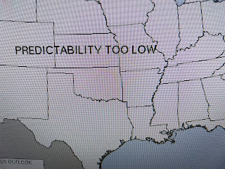
But do you notice the heaviest appears to form south of our coast? IF true, that could limit the Gulf moisture flow so we only get some passing showers for the evening parades. The rainfall totals indicate that, plus look at the SPC 4 day outlook.
So the bottom line is this. Any plans for Saturday's parades should not be changed YET. Friday looks fine/dry with most of the rain gone early on Sunday. Saturday is the issue, but that's still 3 days out.
FOX 8 still has a First Alert for Saturday, but I'm hoping that could change. I could join the crowd and hype up the severe POTENTIAL. However, since SPC is saying it's too low this far out, I'm going to take the route that gives Saturday's parades some hope. In the short term, we stay nice as we enter February.
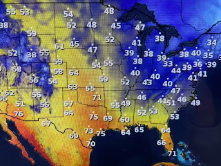
We don't have to worry about any freezes coming since Montana has temps in the 60s!
The bottom view is Alaska's current temps. that shows the Arctic cold (40-50 below) rebuilding again. We'll need to watch for a Polar Vortex sometime during the 2nd or 3rd week in February.


No comments:
Post a Comment