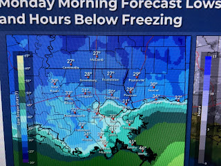
So could it be colder than NWS is forecasting? Yep, since dew points are in the 20s, skies are clear and winds are decreasing. IF the center of the high comes right over us, winds will go calm & temps could approach the dew points.
I've errored on the side of caution since I don't want to lose anything this late into the Winter season. The chill we had this weekend is called a "Blue Norther" in Texas & Mexico and it's pushed down into the Yucatan.
The surface low is near Miami with the upper low over the NE Gulf. As the surface high drifts to our east, we'll see a warm up for the rest of this week. Highs have surged back into the 50s across Oklahoma & Kansas. With no signs of return flow from the Gulf, the next couple of days should see plenty of sunshine.
After tonight's freeze threat, the rest of the week warms up. My plants will be back outside tomorrow. Finally,
Despite all the recent rainy weather, look at all of the fires/smoke that shows up on the daylight/visible satellite view. Actually, there are so many fires, I only circled the bigger ones. All have to be man set as we've seen no lightning with this latest round of showers on Friday & Saturday. Farmers burning debris in their field ahead of planting season? Stay tuned!


No comments:
Post a Comment