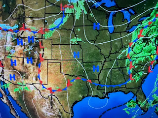
Unlike the last system, my gut tells me this disturbance will bring a higher severe risk and a lower flood risk. The WPC rainfall projection has the heaviest (3-5") amounts well to our north. There may be several "training bands, but amounts south of Lake P. should be no worse than 1=2". Why? Look at the upper air forecast maps.
The California upper low today is nearing the Texas panhandle on Friday quickly lifting up into Illinois & Indiana by Saturday AM and over Ohio by Saturday night. That rapid movement should limit rainfall totals, but increase the forward speed of any T-Storms. A FOX 8 First Alert has been posted, but we have lots of time to see if severe storms develop. In the short term, it's beautiful thanks to a storm over the eastern states.
Satellite views show how some drier air has pushed down into the Gulf and Thursday should again see lots of sunshine and warm temps as we'll be under the upper ridge. South Texas again topped 90+.
There could be some morning fog around again tomorrow as skies will be clear & winds very light.
There is a cool down coming for this weekend, but it won't be drastic. With sunshine & drier air Saturday PM into Monday, the feel will be great! Finally,


No comments:
Post a Comment