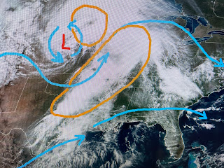
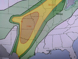
The rain chances for this weekend are not zero, but any shower would be brief and should not make much of an impact. Where it is storming, the upper set up will keep the bad weather there all weekend.
The orange circles are areas of upper-level splitting of the jet streams that results in enhanced lift. SPC outlined those areas yesterday, but look where they move it for tomorrow & Sunday.
Not much difference keeping us with a great looking weekend. There is a lot of upper energy associated with a deepening surface low. Tornado Watches will be up for many this weekend. In addition, the 7-day rain totals have a large 4-6"+ bullseye.
The surface low is creating different seasons around it. Along with warm air streaming northward, there is a surge of 60+ dew points (very humid) all the way north to Omaha.
Locally, we have some wind that really makes the temps feel nice and that should be the case for the whole weekend. The low level cloud streets show up(green arrows) with the upper flow (blue arrows) blowing the wispy cirrus west to east.
So if you're going to the Fest or to watch golf, bring a hat & sunscreen. It's a terrific Spring weekend along the northern Gulf Coast.
Now if we can only get the Pelicans to beat the Thunder tomorrow PM. Enjoy your weekend & stay tuned!


No comments:
Post a Comment