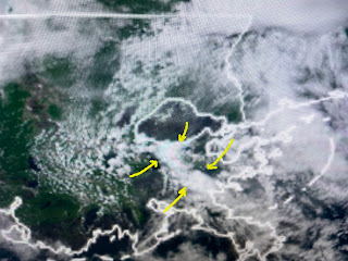
The second view is 11 AM followed by the noon hour. Clearly the storms fired off along some kind of boundary. Radar views looked similar.
In addition to the very heavy rainfall rates, today's storms were the most electrical (Frequent lightning) in a long time. The boundary was apparently the old cold front that stalled out. Temperatures either side were about the same, but look at the dew points to our east.
Until the surface boundary moves, expect our rain chances to continue daily into next week. The key will be, where will the boundary be located day to day?
These daily showers bring us some relief from the summer heat. In fact, today's high of 87 was reached at 9:42 AM, then the storms cooled things off. Models all indicate another, deeper upper eastern trough for next week. Can you say another cold front?
Finally, the area of disturbed weather continues over the southern Caribbean.
Strong west upper winds are not allowing any storms to organize. Tonight at 6:30 PM is FOX 8's Weathering The Storm. Stay tuned!


No comments:
Post a Comment