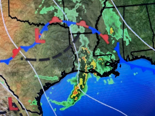
Now I understand, day after day of heavy storms (like in Dallas & Houston) gets old and I won't mind if we dry out for several days. What I don't want is another Summer like last year where an upper high parked over us for months. We really need some daily showers around to temper our heat. The current cluster of storms is rotating around an upper disturbance over NE Oklahoma.
So until we get a change is the upper air flow, expect another round of storms to approach us late Saturday PM.
So since we know what the weather will be for most of the next three months (hot, humid with spotty storms), I'll start focusing more on any Tropical threats as Hurricane Season begins at midnight.
We do have many weak tropical waves to follow, plus old frontal boundaries moving down from the NW. But NHC and computer models have nothing likely to develop during the next 10-14 days. Finally...
For years, my friend Joe Bastardi has been campaigning for a "Power & Impact" scale to supplement the old Saffir-Simpson Cat 1-5 wind scale. Yesterday NOAA posted a video comparing how two recent major hurricanes had vastly different impacts despite being nearly the same Category level. Size really does matter and I invite you to go watch this video to educate yourselves before any threat comes our way. Enjoy your weekend and stay tuned!


No comments:
Post a Comment