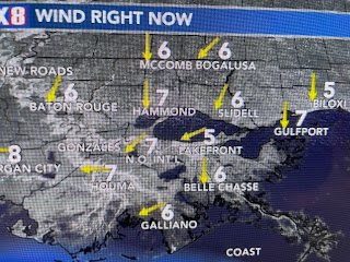
As you go up in height, the air cools. Clouds form when the temp. & dew point equal each other. Now back to the spread. On Thursday, our dew point was 79 with the air temp. 88! The spread was only 9 degrees, August like humidity. Look at today as northerly winds brought our dew points down into the 50s while our temps warmed into the 80s. The spread today is 25-30 degrees and it's why our air feels so comfortable.
But that is already about to change for Mother's Day. We're between two upper disturbances enjoying very nice May weather. The Northeast is cloudy, cool and rainy.
Our sunny skies are about to turn cloudy as the disturbance over the Rockies heads to the east.
70+ dew points are already showing up in south Texas and that's the moisture surge that will bring us a heavy rain threat. SPC's 7 day rain total has the heaviest to our north.
The NWS frontal maps are valid for Sunday AM, Sunday PM, Monday AM with the bottom view valid
for Tuesday AM. SPC has placed us in a level 2 severe risk for Monday.
Storms are already firing over west Texas with the middle graphic valid for Sunday followed by Monday's severe outlook. We're likely to see several waves of rain during the next 3-5 days with some dry days in-between.
Happy Mother's Day but get ready for some unsettled weather arriving by late in the day. Stay tuned!


No comments:
Post a Comment