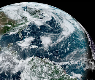
The map describes a simplified explanation of why so quiet. I think a bigger reason is the MJO (Madden Julian Oscillation) has been in the unfavorable (sinking air) phase over our part of the world. Looking back to that 2014 season that started late, finds only 8 named storms developed that year. Before you start feeling great, recall the Katrina year (2005) that didn't start until June 8th (Arlene). We ended up with 28 names that season! Well, models are showing a wetter pattern coming for the 10-14 day time frame with the GFS again developing a storm in the Gulf.
At the same time (Sat. June 15th), the Euro shows no such closed low. It does have some moisture/rain and that's more likely than a named storm. However, the Tropics will come alive sooner or later, but the current pattern is bringing down fronts from the NW.
I've drawn on the upper flow and this pattern keeps anything that might develop in the Gulf or Caribbean away from us. The GFS is notorious for trying to form stuff and then nothing happens. So let's get back to our local weather.
Yesterday we had a line of storms fizzle before reaching us and staying well to our north. Today was just the opposite. A line of storms exploded right on us with a weak feature/frontal boundary struggle to move through. You can't find it on the surface map.
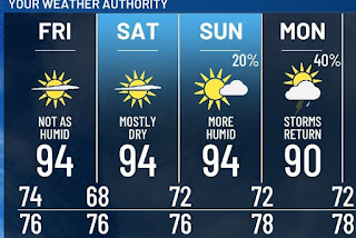
With the upper flow from the NW, look for those lower dew points/drier air to slowly move in for this weekend. That should bring back the sunshine and heat us up.
Next week could see some tropical moisture return which should result in typical daytime heating storms. Until then, get ready for some basic June heat. Compare that with today where those morning storms & cloud cover kept us in the 80s.


No comments:
Post a Comment