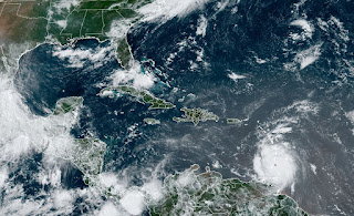
I know improvements in technology allow NHC to detect things that years ago would go unnoticed. If case you missed overnight, Tropical Storm Chris has come and is gone. Yep, another 12 hour storm that is now inland over Mexico. Personally, I think NHC could have kept it as a T.D. since it was so close to land. But because aircraft detected minimal T.S. force winds, it's another wasted name.
But the main weather story for this week will be Major Hurricane Beryl as she streams westward over the Caribbean. Her satellite structure continues to be one of a classic storm.
The bottom view now shows Beryl leaving the Grenadines with the eye entering the eastern Caribbean. So you all want to know, where she will go and do we need to worry or forget about her? Let's begin with the NHC thinking.
Without the centerline track, you can clearly see a path making landfall near Belize or the Yucatan. Models continue to show a weakening trend the farther west Beryl moves due to increasing upper wind shear. So what should we be looking for into the next two days? Let's add on the centerline track.
RIGHT NOW, that centerline track is well south of Jamaica with the northern cone of error/uncertainty crossing the island. We want that track to keep trending to the south as that would lessen any future threat to the northern Gulf coast. Since we have the upper heat dome over us for the rest of this week, I favor that solution.
But before some of you blow off Beryl as no0 threat, the spaghetti plots still have several models that turn Beryl to the North. My point is, follow the centerline track as this system moves south of Jamaica. IF that proves reality, then we are in the clear. But I've been at this "game" long enough to IYKYK! Sorry Morris! You should expect the unexpected until the it becomes obvious. Right now, my gut says this will never be a threat to Louisiana. Jamaica & the Caymans will get hammered and so could Cozumel & Cancun. I'll post again around 4 PM. If you can, take the poll abour future podcast. Stay tuned!


No comments:
Post a Comment