
This post is to add on to the information the NHC and other Tropical blogs put out. I remember days ago ready the NHC discussion talking about Beryl's future intensity after crossing the Yucatan. The Hurricane Specialist wondered if Beryl would be able to regain strength after the circulation would be disrupted by crossing land? Well, it hasn't so far and the window for getting stronger is closing. This is what we know for certain. Beryl has about 12 hours left to get stronger. She probably will become a Cat. 1 or a Cat. 2 at worse. Thankfully, She can't ever get back to the Cat. 4 or 5 that hit the Islands earlier this week. Satellite views look impressive, but Recon data still has her a strong Tropical Storm.


NHC's discussion indicates some drier air still surrounds Beryl, but all models show intensification tonight. We shall see. Really doesn't matter much anymore as all preparations should be complete. The official centerline track again nudges to the right/east.


The middle map is from the 4 pm NHC advisory with the bottom being from 10 AM. The shift to the right is small, but any further shift to the east will place Galveston in the eyewall IF Beryl intensifies. Seeing TWC showing folks walking the beach in Galveston tells me they are not evacuating for this storm. Hope they are not surprised?


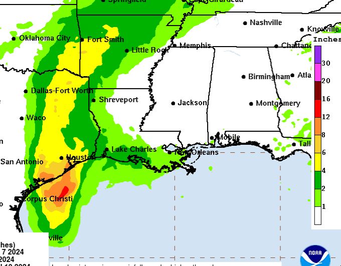
The radar view shows an eyewall trying to form with a strong band across SW Louisiana back over Houston. NHC has decreased the total rainfall amounts keeping the heaviest from Lafayette westward.

The future track pulls Beryl northward and then to the NE as an upper trough picks her up.


Clearly the storm surge & greatest wave heights are heading into Texas. What we have to watch out for will be any heavy bands rotating around Beryl tomorrow and Tuesday that might train over the same area for awhile.
.jpg)
Otherwise, our forecast is basic summertime. Stay tuned!
No comments:
Post a Comment