In my last post, I mentioned Hurricane Agnes back in 1972 when I was a "rookie"(1st Hurricane) under the mentorship of the late Tampa Legend Roy Leep. At 24 years old, I was scared and not sure how to handle Tropical Threats. Roy, at 39, was a seasoned veteran and displayed the calmness & confidence only experience can give. How lucky I was to learn from Roy. He taught me and had the personal abilities where he wasn't scared I could take his job. Tampa was his home for over 40+ years and he knew by making me better, I would go somewhere and become the "Chief Met". Roy was right.
WTVT-TV Ch. 13 named their weather center in Roy's honor for serving them for 40 years (1957-97). I feel blessed to have served the best. But back to Agnes. We only received two satellite pictures a day back then and they were grainy & in black & white.
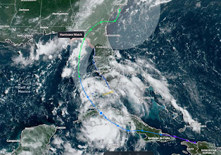
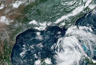
The track is a little different than Debby's, but my point here is Agnes became a killer flood storm as she moved inland & northward.(Google her) The worst part of Debby may not come until she reaches Georgia & the Carolinas where she could stall for days. You folks there BEWARE! NHC has upgraded TD 4 to Debby based on satellite structure & buoy data plus radar.
Now that it's over water and we have a well defined center, we should have more confidence in the computer model forecasts.
At 48 hours out, the NHC error cone shrinks down to 60 miles. As you can see, the problem comes once inland. Landfall is predicted for Monday PM, but note over the next 3 days Debby will stagger over Georgia & the Carolinas. As I mentioned in my last post, the danger has shifted from south & central Florida to north Florida and GA, SC, & NC. Doesn't mean you'll get no impacts as a feeder band could set up over you. But the real impacts will be the Big Bend area once again.
Look at the updated rain totals forecast. Fort Myers, Tampa & Orlando might get 2-3", but Savannah to Charleston to Myrtle beach could see 12-20+"! Yikes. You still have time tonight and Sunday morning to load up on supplies if you haven't already. So why has Debby made the turn and why will she stall? Look at the upper air.
An East coast upper trough is diving down over the Ohio Valley. Fortunately, it has turned Debby to the north. But, unfortunately, that trough will lift out too quickly leaving Debby behind much like Harvey over Houston. For us, as Debby gets stronger, we will be on the dry side so maybe we'll see the lower dew points (50s, 60s) will wrap around her western side.
Don't get use to much cool air as the Heat Dome is coming back big time next week.
Heard from my Friend Tom sitting at the Sarasota Yacht Club having an afternoon beverage. For us here and along the northern Gulf, Debby is not our storm. For much of Florida, this is not their storm. But for some, Debby is likely to have some severe impacts and could be stronger than a Cat One at landfall. Don't be sitting at your local bar waiting for Debby. Pay attention to your local emergency managers and follow their orders. Stay safe and stay tuned!


No comments:
Post a Comment