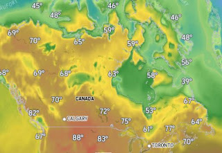
In this Hurricane Season that was supposed to be "hyper-active", we chug through the last two weeks of August with nothing happen now & all models not developing anything during the 10-14 time frame. Sure, September & early October could go nutso, but the longer we stay quiet, the closer we get to cold fronts coming down south steering storms away to our east. Canada is getting cooler and so are the northern states & Great Lakes.
Folks up there need sweaters & jackets, but it'll be awhile before we need them. BUT, when Costco starts sending out emails advertising Fall fashions, you know it's only a matter of time. While we sweat, the Tropics remain dead, except for Ernesto well off the East Coast.
There remains a boundary over the southern Gulf, but it is not doing much. We are on the edge of the Heat Dome with the East Coast upper trough bringing down relief for folks up north. We could see several rounds of storms rotating around the Heat Dome late tonight & on Monday.
Today we're between the low level moisture in the Gulf and the frontal boundary to the north. Rarely do you see a day in August with no rain between Houston & the Florida beaches.
With no rain around, it's smoking hot again. Not as awful as last August, but we're close.
We'll see a slow cooling this week, but we're no where done with Summer. Finally...
If skies are clear, we'll see a huge "super moon" that happens when the full moon occurs when the moon's orbit has it closest to the Earth. Probably will look cool tonight too? Stay tuned!


No comments:
Post a Comment