Monday, September 30, 2024

Gulf Development Decreases In Short Term, Cold Fronts Coming, Beach Is A GO!

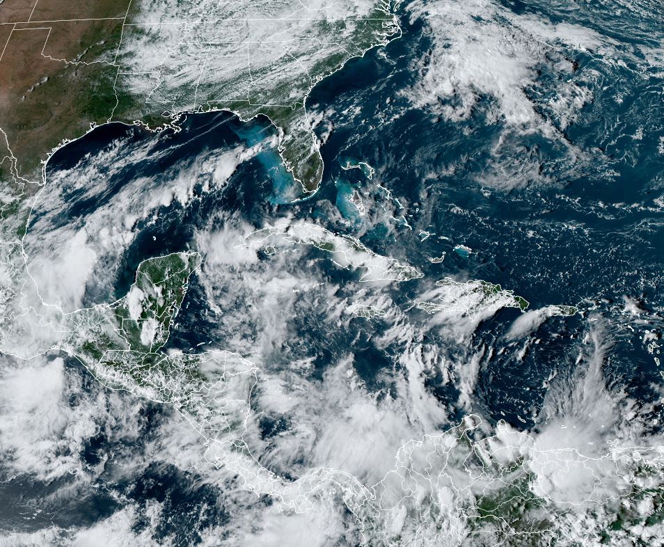
I was happy to see the NHC's T.W.O. decrease from 50% to 40% this morning and remain there this afternoon.  The set up this week is entirely different from Helene's last week.  Recall, ALL models were developing a well defined circulation in the Caribbean and moving it into the eastern Gulf.  I've already mentioned how accurate models were with Helene.  This week, NONE of the models are developing a well defined system and let me try to explain why.  We begin with the Water Vapor that has strong SW upper shear over the Gulf  and there is an upper low moving westward over the Caribbean.  Both are creating a hostile environment for development.


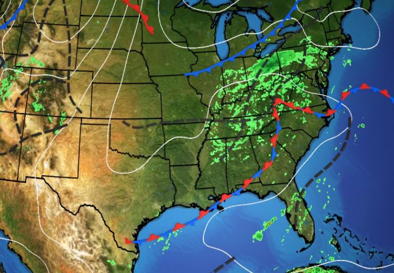
NHC has highlighted a large area for possible development, but not during the next 2-3 days if ever. The X at the bottom of the graphic is where NHC believes some spin could start.  Nothing is there yet.


In addition, look at what Helene did to the Oceanic Heat Content over the eastern Gulf.  The Northern Gulf is already cooling, but you can see Helene's shadow off Florida's west coast.  IF something were to start forming, there's plenty of warm water over the Caribbean, but the Gulf is not as warm as just a few weeks ago.  Those things are in our favor.


There is a leftover frontal boundary across the central Gulf, but until the old circulation from leftover Helene to our NE lifts out, that boundary will only slowly shift back over us.  My Beach Trip is on and I have until Wednesday PM to decide what to do.  Remember, us "old folks" don't sit out in the sun anymore. (4 squamous cell cancers so far!)  We go to the beach for the sound of the waves, the smell of the air, the sitting under umbrellas (with sunscreen) sipping our medications!  I'll keep updating those of you traveling there with me. For now, I'm excited to see cold fronts coming.


The front coming down over the Plains is not going to bring us sweater weather, but it should be enough to turn any tropical disturbance away to our east this weekend into next week.  Temperatures do fall from the 80s into the 50s & 60s behind this front, but a much stronger front will come down after Oct. 15th.  It's got me reaching out to "The Lady" to find out whether she's available around Oct. 20th.  So far, we have seen 4 landfalling Hurricanes in the northern Gulf.  That track pattern may be changing to back over the Atlantic?


All those storms out there will not come our way now that fronts are coming.  We'll keep an eye on closer to home areas like the western Caribbean & Gulf. You can see that drop off in names last year.


Hope we see the same drop off this year as we get deeper into October.


As we leave September, total rainfall of  17.37" at MSY makes this the 2nd wettest September going back to 1946.  Only Sept. 1998 at 18.98" was wetter.  Finally, there were several asking why Helene was worse in the Carolinas than along the landfalling Florida coast?


The videos have been stunning and depressing, but look why the flooding was so much worse.  North Florida had up to a foot of rain while some locations in N.C. topped 30" !!!  Plus their terrain is mountainous vs. Florida being mainly flat.  Beginning tomorrow, you can get another dose of  the Breckster.


"The Southern Charm Of Bob Breck".  Really?!!!  Stay tuned!

Sunday, September 29, 2024

Models Not As Bullish, Gulf Development Still Possible...

I've mentioned in a previous post that we're going to the beach (Perdido) for my B-Day, a trip that has been planned for months.  But Bob, it's still very much hurricane season!  Duh, that's why you get insurance in case a storm changes plans.  I am not about to cancel until I see something form, and nothing is there yet. There is just something about seeing the beach & water, especially if you're looking out from an upper floor condo balcony.


Look how attentive Bailey is looking out over the water!  The bottom is Brenda's beach bride getting ready to walk outside for the ceremony.  You can view more of her art work at www.brendabreckart.com.  I'm getting excited, but I also know I could be disappointed IF something forms in the Gulf late next week.


One thing that is different from last week (Helene's set up) is the upper air.  The bottom view is the water vapor that has the usual upper high off the East coast, but upper lows from the southern Gulf to the central Caribbean.  Upper lows indicate the environment in the short term is hostile for development.  Perhaps that is why NHC did not increase the chances for development on their Tropical Weather Outlook (TWO).  Also, I'm sure most of you who constantly monitor model runs have seen how all are not pumping something up like they did before Helene.  We keep watching and not cancelling plans whether for the beach or Disney World.


This week will be very summer-like starting out with lower humidity.  That
will slowly change as tropical moisture returns late week.


So let's keep enjoying our sunshine & keep praying for those still suffering from Helene. Look at this graphic.


Helene was an enormous storm that brought some locations 1-2+ FEET of rainfall.  I've seen videos of unbelievable destruction with interstate roadways washed out.  Sad to watch and they don't need any more.  Stay tuned!

Saturday, September 28, 2024

Bob Is Everywhere, Plus Northern Gulf Threat Increasing For Next Weekend

 Gosh, I'm almost embarrassed to see all the coverage on me, beginning with today's Times-Picayune/Advocate.  I'm featured with my wife Brenda in the living section.  It's a wonderful article about my gardening skills/luck, plus Brenda's art work that adorns our house.  Hope you enjoy reading it?  But there's more Lee Zurik! 


I want to thank Jonee Ferrand, owner & publisher of INSIDE NEW ORLEANS, for selecting me to be in the "Southern Gents" feature in her magazine. It will be out on October 1st. Be sure to pick up your copy at the following locations.


But let's get back to what appears to be yet another northern Gulf tropical threat for next weekend.


As you can see, there is NOTHING THERE yet.  But just like with Helene last week, models are developing something in the NW Caribbean by Thursday or Friday.  I said yesterday I wouldn't show any model solutions until something forms, and I'll stick with that thinking.  Many are posting the Euro, GFS or Canadian solutions for next Sunday on line like they will be correct.  Well they all have different solutions and none of them could be correct.  Let's take a deep breath and just wait until something forms before we go to our Xanax, vodka or rum.  One thing for sure, the systems out in the Atlantic will not be our future problem.


The next named storm (Kirk) will probably be the wave coming off of Africa.  He will turn to the north and stay away from us.  What we need are cold fronts!  Not happening until upper pattern changes.


Alaska & Canada are getting cold (30s & 40s), but none of that can move into the U.S. until the pattern changes.  That's why we still have to watch the Tropics.


The remains of Helene continue to soak the Ohio Valley and that will be good for us as that rainfall will increase flow down the Mississippi River.  As the increase in flow reaches us, the salt water wedge will be pushed back towards the Gulf. So we're still summer-like with highs around 90 for another week.


The increase in rain chances for Friday & Saturday will come from that potential storm in the Gulf.  Enjoy the rest of your weekend and the Saints win (33-30) over the Falcons tomorrow on FOX 8 at noon.  Stay tuned!


Friday, September 27, 2024

Say It Isn't So, Another Tropical Threat In Gulf For Late Next Week?!!!

 Here we go again, computer models hinting something will form that is not there yet.  Sound familiar?  It should since models had Helene forming 7-10 days in advance.  This time, the models are not as bullish at developing a strong system like they were with Helene.  However, since we have been in the favorable phase (rising motion) of the MJO, we cannot ignore, we are still no where near the end of this hurricane season!


I know many of you go look at all the models so I won't post any here until something develops.  I mentioned yesterday, I have a beach trip for next weekend.  I don't want another threat along the northern Gulf coast.  Will there be one?  Perhaps, but it's way too soon to start changing plans.  We're back to watching and waiting.  What will end this Hurricane Season for us?  Cold fronts!, but there are no signs of another front coming until the upper pattern changes.


We currently have a cut off low located near Memphis.  It has captured and absorbed what's left of Helene near Louisville.  The main jet stream enters the Pacific NW and streaks across southern Canada locking in any colder air far north of the lower 48.  Helene's circulation and the cut off upper low has brought down much drier air to us.  That will last through the weekend into next week.


This morning was the coolest (66) since back on April 30th.  With dew points in the 50s, tomorrow morning will feel the same.


So it looks like a great weekend for any outdoor activities here.  But lest we forget, the Tropics have awakened. Way out in the Atlantic, Hurricane Isaac has an impressive satellite signature.


But Isaac is moving out over the Atlantic and is no threat to land.  Tropical Storm Joyce has formed way east of the Islands.  She too will stay out to sea.


So let's look back at Helene.  Here are my thoughts.  Computer models did an excellent job 5-7 days out zeroing in on the Big Bend area of Florida.  Here's the NHC landfall 5 days out.


To me, that's incredible accuracy!  Bravo NHC!  But they weren't alone.  Look at the track AccuWeather put out BEFORE the NHC track.


Not bad even if their cone was way too wide.  The new storm surge forecast from NHC was terrific.


Tampa Bay ended up with 7.2 feet of surge, the greatest in modern times.  And that came with the eyewall staying 100+ miles offshore!


I've seen the videos from Pinellas County, FL. showing how the surge brought boats into people's yards and water into many homes.  Hard to believe, but this was NOT the big one for Tampa Bay.  A shift in track 30-40 miles to the east would have made neighborhoods from Sarasota to Clearwater to Tampa uninhabitable for weeks and months.  That happened to the Fort Myers area after Ian.  What you should learn from this storm is this. RESPECT the power of moving water.  If you live long enough, you could see the big one. Run from the water unless you have elevation higher that the predicted surge.  Prayers for all those hard hit from Florida into the Carolinas.  The death toll has now passed 40. Zack Fradella had thi9s graphic this morning.


Helene makes it the 4th U.S. hurricane landfall in 2024.  Back in 2005, 2 of the 5 landfalling storms occurred in October.  Sorry to tell you, We are NOT done with more Hurricane threats this season.  Enjoy your weekend, but start paying attention again next week.  Stay tuned!