As I mentioned in yesterday's blog post, several models are hinting that a strong disturbance will form in the NW Caribbean early next week and strengthen into our next named storm (Helene). The big question remains, where will it go? The Euro takes it over the western Gulf as a weak system while the Canadian & GFS bring it over the eastern Gulf. Should we believe either? Nope, too soon as nothing is there yet. But NHC has begun highlighting the area for development.
There is a small cluster of storms east of Nicaragua, but I don't believe that is what models are developing. As you can see, the Gulf & NW Caribbean are quiet. I know anyone can look up the computer models and freak out. You shouldn't do that as models will flip flop beyond 7-10 days. Here's what the Euro, Canadian & GFS models have for solutions for late next week. On top is the Euro with a system in the western Gulf.
The middle is the Canadian with the GFS at the bottom. All views are valid for next Thursday. What we don't want to see is another storm that goes to our west putting us on the stronger side. Only the Euro does that. IF you are a betting person, it's likely this system will go to our east since Louisiana has been the target for landfall during the past 5 years..
History has told us that storms/hurricanes tend to cluster around locations for a short period of time. (Florida in the 40s & 50s, 00s). It's time for that location to find another state! Since we remain in the heart of the hurricane season, let's just pay attention early next week in case something does form. Until then, we have a "nice" stretch of heat coming for this last weekend of summer. Fall arrives on Sunday.
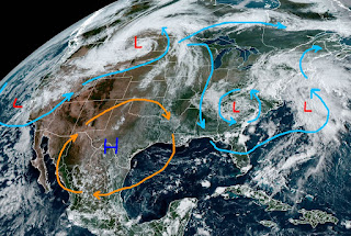
A deep upper trough over the western states is bringing a Fall feeling to them. Even Phoenix struggled to reach 90. We need that upper trough to reform over the eastern states for us to get a real Fall feeling front. Not happening anytime soon.
Gosh, it seems like summer will never end. I don't like real cold temps, but C'mon 4 months is enough!
Saints tailgating on Sunday looks dry but hot. Just to give you some hope, it snowed over the mountains outside Park City yesterday.
It's only a matter of time Gang. Cooler air is coming next month! Stay tuned!


.jpg)
.jpg)

No comments:
Post a Comment