
NHC has finally found a center of surface circulation over the western Caribbean and upgraded PTC 9 to Tropical Storm Helene on their 10 AM advisory. Now with a correct initialization point, computer models should give us more confidence on future model solutions. There will be a major Hurricane making landfall later this week. Fortunately, it will not be our issue. NOLA, being a majority Catholic community, often prays to Our Lady of Prompt Succor to protect us during hurricane season. We need to also pray for our friends in Florida with this storm. Some of my wife's artwork are called "prayer sticks" or "spirit sticks".


Native Americans often used these sticks to pray for rain or for the "spirits" to intervene in whatever they needed. If you want to see more of Brenda's artwork, just go to her website (www.brendabreckart.com) and click on Gallery.


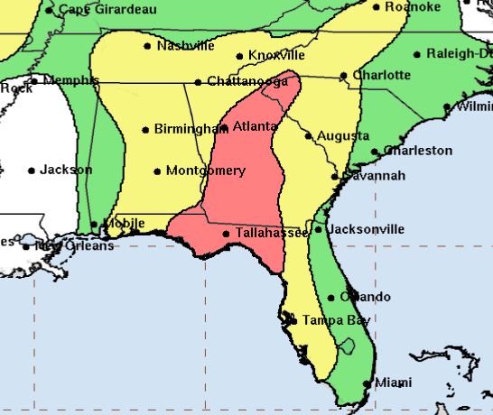
Most of you have seen all of these graphics that NHC puts out and they have been very consistent in their messaging. I'll add a word of caution to all folks living along Florida's west coast that( RIGHT NOW) are outside the cone of error. Remember Francine's path as she approached SE Louisiana 3 weeks ago. she had several not forecasted jogs to the right that brought the brunt of the storm over New Orleans. Any shifts in the centerline track over the next two days will bring greater impacts to those currently outside the cone. Pay attention! The Spaghetti Plots are tightly clustered over the Big Bend area.


Notice how the heaviest rains are just off Florida's west coast. Since this will be a fast moving system, impacts will be felt well inland. Saint's fans traveling to Atlanta should be aware they will have some wind & flooding issues on Friday as the bottom graphic is called Flood Potential. So why are we protected?

My last post detailed an upper low diving down from the Plains that will steer/turn Helene away from SE LA/MS/AL. As the weakening upper high slides to the east, Helene will enter the Gulf tonight and start to move to the north. That digging upper trough will create strong WSW winds turning the storm away from us. Unless something drastic were to change, this is Florida's storm. Let's open up our prayer lines for them. Next post after 5 PM . Stay tuned!
No comments:
Post a Comment