
Believe it or not, I do try to read all of your comments you make regarding my posts. Many of you enjoy & trust my opinions, while some obviously just don't like me. Reminds me of one of my mentors (John Coleman, founder of TWC) telling me "if you try & please everyone, you'll end up pleasing no one". I follow the blogs I LIKE. For the life of me, I can't figure out why those who dislike/disagree with me still bother to follow me? Give yourself a break. Go follow other bloggers! I'm taking a different approach today as I know most of you know where to go to see all the models. Rather than alarm/cry wolf when the wolf may never show up, let's begin with what we KNOW. Currently, the Gulf is a hostile environment for tropical development during the next 2-3 days. A Heat Dome is over Texas shifting our way with a deep upper trough bringing screaming northerly winds all the way down over the Yucatan.


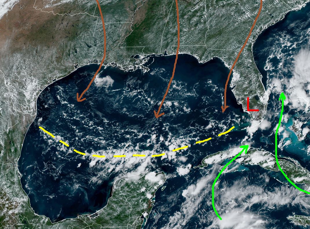
A broad area of low pressure (Central America Gyre) is trying to form over Honduras & Nicaragua. Since the low is mainly over land areas, development will be very slow. However, NHC has increased the probabilities for development up to 50% for NEXT week.


One thing to note is how the western & northern Gulf have been cooled by Francine last week. The upper Heat Dome is predicted to shift over us by Sunday as the eastern trough pulls out to the NE. You can see how most of the Gulf has been swept by drier air that shows up better on the water vapor. (bottom view)


This environment will not allow tropical development. However, that pattern will change next week as an upper trough digs down over the Central Plains allowing an avenue for a Gulf disturbance to more northward. The top view is the current upper air Heat Dome.


The GFS then forecasts the Heat Dome to move off the East coast with the upper trough centered over Missouri. The middle view is valid for Wednesday PM with the bottom valid for Friday PM. There are many other model solutions and you can go check them out. Until something actually forms, I choose not to speculate. What I can say with some certainty is, there will be a Tropical Disturbance somewhere over the Gulf later next week. We will have plenty of time to restock our supplies, if you haven't already. Do NOT put out your Halloween decorations! In the short term, this final weekend of Fall will be very hot.


It appears next weekend will be cooler. Let's hope it's not due to another hurricane threat?!!! What you need to watch for when looking at the daily model runs is 1) will we be on the weaker side of whatever forms (very important!) ? IF the system goes to our east, impacts here will be minor. Right now, there is no consensus on model agreement. Nothing has formed yet.

There are clusters of T-Storms (Reds/oranges) east of Honduras & Nicaragua but nothing is organized. Best thing for us is this area does develop and move into Central America and never get into the Gulf. Watch & pray this weekend that it won't become our problem. Fall begins Sunday at 7:43 AM. Stay tuned!
No comments:
Post a Comment