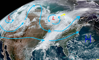
It's been 26 straight days (record dry spell 44 days in 1952) without rain that finally ended today. For three days computer models have been advertising 60% chances while I suggested that might be too high. Well, reality shows us that was too low as many areas across our state are getting good soakers. The bulk of the showers have been to our west, but the trend is shifting slowly eastward.
All these clouds and showers are along a slow moving cold front that will stall out near us. Hopefully, the rain keeps coming over night as we need several inches to make up for almost 4 dry weeks.
Record warmth has surged into New England while the air behind the front is noticeably cooler. It was a wet snow for much of the day in Minneapolis. This front will stall out and retreat back away from us for the weekend as the upper low over the Great Lakes is not diving down into the Southeast.
Expect more summer-like warmth well into the first week of November. When the cold finally does come after the 10th, I expect it will be a sharp drop off . Finally, models won't give up on the Tropics.
As you can see, there is nothing there yet. As Jim Cantore pointed out again today, there have only been 4 hurricanes in the month of November that made landfall in the Gulf...and NONE have crossed the Louisiana coast. Bring on those fronts! Stay tuned!


.jpg)


No comments:
Post a Comment