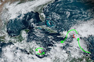
Many computer models are now hinting at a Tropical Storm or a Hurricane will form this weekend in the Caribbean and enter the southern Gulf next week. With cooler waters and stronger upper shear across the northern Gulf, I expect whatever forms to either head into Mexico south of Brownsville or turn up over the eastern Gulf off Florida's west coast (again!). As I've mentioned before, there has never been a hurricane cross the Louisiana coast in November. It'll add to the name totals, but will not become a major system unless it stays over the warmer Caribbean waters. Right now we have two areas to follow.
Our concerns are when we'll see our next cold front? Until the upper pattern shifts, not for another 7-10 days as the trough remains over the western states with a ridge over the East.
A front has stalled to our west, but it got close enough to bring clouds and showers. In fact, a boundary set up last night across the North Shore triggering 4-8" of rain in spots and that boundary is just to our west today.
So the front should lift northward for the weekend allowing some sunshine to return. We'll stay Summer-like through next week.
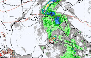
So back to the Tropics. Here's what the models do with the Caribbean system. First the GFS valid for Wednesday Now. 6.
It takes the disturbance westward towards the Mexican/U.S. coastline by the following Tuesday 11-11. The Euro is way less bullish.
It has a weak circulation NW of Cuba next Wed 11-6, but weakens it into a wave by Friday. Hey, we have nothing else to watch since the cold isn't coming until after the 10th. My feelings for late November into December haven't changed. IF the western trough reforms over the Great Lakes and East coast, we'll see a much colder weather regime set in. I remember back in 2008, when I had rotator cuff surgery, it snowed around Dec. 10th. All you snow geeks, keep the faith. There is no "normal" anymore. Just extremes! Stay tuned!


.jpg)


No comments:
Post a Comment