As I get ready to go see my Grandson in Oklahoma City, I think back to the 70s & 80s when we didn't have any numerical temperature forecasts. I had a degree in Meteorology, but going home to northern Indiana was still a challenge since there was no 10 day forecast. But look what we have now. I use The Weather Channel's graphic, but I could have used Weather Underground, Weather Bug or many others. It even shows the current temp. before the 10 day. Wow, what a drop coming!
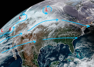
I can easily see I'll need the heavier weather gear, but these are not the frigid temps you could see by Christmas. We still have that persistent upper trough along the West Coast with generally a west to east flow over the nation. You can see that in the temperature contours.
IF you're traveling across the South, you'll have no issues with icy weather. Until that Western trough reforms over the east, we will not get real cold again.
When will that happen? The GFS model says by a week from tomorrow when the trough reforms over the Northeast.
The NWS 6-10 day outlook has the eastern states getting chilly as the cold will come in waves/surges. For us, a weak front will near us Tuesday, but a stronger one arrives for late Thanksgiving.
I still believe December will make up for a warm October & November. In the short term, the next 4 days look warm.
The cold surface high has shifted to our east with south winds bringing back warmer air & the muggies.
Our dew points are already back above 60 and you could just feel the difference outside this afternoon. It'll be almost summer-like for the next 2-3 days with some morning fog a possibility. I have a predawn flight out tomorrow so I may not post again for a couple of days. Enjoy the holiday, especially if you're lucky enough to be with family. Peace & Joy. Stay tuned!


No comments:
Post a Comment