Tuesday, December 31, 2024

2024 Ends Warm, Arctic Cold Coming In Surges.

 A weak front has staggered off the LA/MS coasts bringing drier air for tonight's New Year's celebration.  Some cooler air arrives for Wednesday, but it's not the real cool down coming for next week.  IF models are correct, a huge dip in the upper air pattern will bring down Arctic air that could bring us freezing temps in the 5-10 day time frame.  I grabbed this graphic off of Zack Fradella's morning weather program.


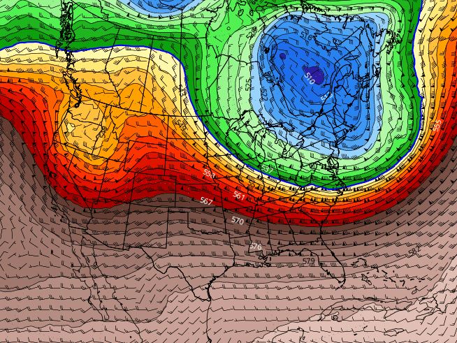
That can't happen until the East Coast upper trough returns.  Right now the pattern has a mainly west to east upper flow over the southern states.  Even though we'll be cooler for the next several days, it's not the Arctic blast coming after Jan. 6-7th.   Here's the GFS computer forecast showing why the chill will drop out of Canada.  We begin with today's flow with a small dip over Illinois.


That dip lifts into the main vortex over eastern Canada by Saturday with generally a NW flow over us.


Fast forward to next Friday and see how the upper trough deepens allowing a north to south flow into the U.S. That flow continues through the following week the this graphic valid for Jan. 16th.


That's 2 weeks out, and we know from the uncertainty of Tropical systems at 10-14 days, a lot could change.  But IF the computer is correct, look how cold it's getting up in Canada & Alaska.


We have no freeze threats in the short term and will have all weekend to watch whether we'll need to protect our plants for the following week..  For now, let's enjoy the New Year.


There is some cooler air coming in from the NW, but it is much drier too as dew points fall into the 30s.


You'll notice a different feel to the air later this evening as the northerly winds increase.  IF you're dressed for it, it will feel great!  Note the huge Arctic Blast coming for NEXT week.  Freezes probable, snow not likely, but there's always hope when it gets cold enough.  Stay tuned!


Sunday, December 29, 2024

Cooler For New Year, Artic Outbreak, Southern Snows Possible 2nd Week

Fortunately, last night's storms had more bark than bite with limited damages & minor flooding.  Yes, 2 people were killed, but SPC indicated it could have been far worse.  Rainfall amounts were generally 1-2" despite all the thunder & lightning.  It was scary at times, but the upper system actually weakened as it moved through.  Today it has lifted to the Ohio Valley with no severe storms, but lots of rain.  For late December, one would expect some snow on the north side of the low, but it's all rain.


It can't snow without cold air and there is none over the lower 48.  The front that staggered through over night has stalled over the Gulf and only a little drier air has moved in.  Note, dew points remain in the 50s behind the front and that low level moisture could mean more dense fog is likely tomorrow morning. Satellite views show a slight eastern upper trough, but that's lifting out.


We'll see another cold front push through late Tuesday clearing us out for the evening's fireworks.  It will cool us to seasonal temperatures for the rest of this week,


For all you snow geeks out there, I'm seeing a deep dip in the jet stream over the eastern states for the 2nd week in January.  Here's the upper air forecast for Jan. 10th & 12th.


IF that proves valid, there will be freezing temperatures plunging off the Gulf Coast down over Florida.  Well, if we get cold enough, could we see snow?  Maybe.  Here are the surface maps for Friday Jan. 10th and Sunday the 12th. The top view does have a low down in the Gulf south of us.


As the low lifts to the NE, it will draw down the Arctic air behind it.  The bottom view for Sunday the 12th has freezing temps even down to the South Shore.   A lot has to happen between now and then.  1st off, Canada has to get cold.


Some bitter cold is starting to show up in Alaska and we'll have plenty of time to watch it during the next 10-14 days.  Still, wanted to give you cold weather lovers something to look forward to.  After another Saint's miserable performance, we need something to cheer us up!  Maybe some snow?  Stay tuned!

Saturday, December 28, 2024

Severe Potential Increasing Between 8-Midnight, Pay Attention Evening

Nothing has changed in the thinking regarding a widespread severe weather outbreak.  In fact, there are many severe storms currently being tracked on radar and warnings are out.  Locally, it's been a fairly quiet afternoon and SPC has re-positioned their Tornado Watch to closely fit the current storms.  The watch goes through 9 pm and more watches are to come.


The western and northern parts of Louisiana are currently under the gun, while we still have several hours to wait and watch.  The strongest cells are from Lake Charles up to Monroe.  The North Shore does have a strong storm northeast of Baton Rouge moving quickly to the NE.


We are fine if you need to run an errand during the next 2-3 hours.  But I want everyone to PAY ATTENTION to their FOX 8 Weather App this evening as warnings are likely after 7-8 PM.  After midnight cooler and drier air will filter in as the upper disturbance lifts to the NE. It is currently just east of Dallas and much farther to the south compared to previous upper systems.


Anytime you can see texture on satellite views tells me there are tall/high cloud tops  The surface front is nearing Houston and should reach us long before daybreak.


Note San Antonio is 82 in sunshine so the cooling behind this front is limited.  However, look at the difference in dew points with Houston at 66 degrees while San Antonio has dipped to 33.  The good feel air is coming back for several days.


We could easily top 70 tomorrow if clouds clear as the west winds eliminate the Lake Effect.  Another, stronger cold front arrives late week, but it will not be an Arctic front.  So where's the cold air?  Signs are showing up in Western Alaska and Siberia that by mid January, a real Arctic Outbreak could bring us a freeze threat.


Yep that's 50-60 below zero temps over Siberia.  I'll be watching to see if that spreads into Alaska next week.  Finally,


At 4:40 PM look at all the lightning that accompanies the storms to our west.  Again I stress you have your FOX 8 Weather App set up to receive warnings later tonight as I fear they will be coming out fast & furious.  SPC is calling this a Particularly Dangerous Situation (PDS) with the potential for strong, long track tornadoes.  Be ready to duck into your "safe room" if you are warned.  Let's hope they weaken as the upper system lifts away. Stay tuned!

Pay Attention Saturday, Tornado Watch North Shore

This is a quick post to remind you that we have the "Potential" for strong storms later today, especially after dark.  Many of you know I enjoy golf since I can play that game despite my small size.  Years ago, the PGA had a promo showing Tiger Woods, Phil Mickelson and others making spectacular shots with the announcer saying "These guys are good".   I feel that way with the forecasters at NHC & SPC as they are specialists in their field.  It's not very often you'll see SPC (Storm Prediction Center) put out a level 4 (moderate) severe risk, meaning they are very confident strong tornadoes will develop within that area. These guys/gals are that good!


Clearly, the highest risk is just to our north, however, the North Shore is under a level 3 with a Tornado Watch in effect until 3 PM while the South Shore is a level 2 risk.


Those watches may be extended to include the South Shore too with coastal Mississippi later tonight.  This Severe risk is due to a powerful upper trough diving into central Texas. We are in the warm air sector with temps in the 70s.


From what I'm seeing, this will be a widespread outbreak of severe storms covering many states,  There are two areas of strong storms affecting SE LA/MS this morning.


All of the radar images are from 10:45 AM.  Use your FOX 8 Weather App to keep up with the latest radar views.  For now, I believe the worst/highest severe threat arrives towards dark and continues through midnight.  A weak surface front will bring slightly cooler, but much drier air here for Sunday & Monday.


With temps 75-80, dew points 70+ and shifting winds with height, it appears all the ingredients are there for nasty storms marching from Texas across Louisiana.  It is a Pay Attention Day.


Our next real cool down won't arrive until late Tuesday night.  There could be some dense fog around for the fireworks.  It's back to sweaters & jackets late week, but the Arctic air should stay well to our north.  If you're traveling around this afternoon & evening, track those storms on radar so you're not surprised.  There could be some brief street flooding to go along with the severe threat too.  Stay tuned!