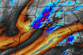
Nothing has changed in the thinking regarding a widespread severe weather outbreak. In fact, there are many severe storms currently being tracked on radar and warnings are out. Locally, it's been a fairly quiet afternoon and SPC has re-positioned their Tornado Watch to closely fit the current storms. The watch goes through 9 pm and more watches are to come.
The western and northern parts of Louisiana are currently under the gun, while we still have several hours to wait and watch. The strongest cells are from Lake Charles up to Monroe. The North Shore does have a strong storm northeast of Baton Rouge moving quickly to the NE.
We are fine if you need to run an errand during the next 2-3 hours. But I want everyone to PAY ATTENTION to their FOX 8 Weather App this evening as warnings are likely after 7-8 PM. After midnight cooler and drier air will filter in as the upper disturbance lifts to the NE. It is currently just east of Dallas and much farther to the south compared to previous upper systems.
Anytime you can see texture on satellite views tells me there are tall/high cloud tops The surface front is nearing Houston and should reach us long before daybreak.
Note San Antonio is 82 in sunshine so the cooling behind this front is limited. However, look at the difference in dew points with Houston at 66 degrees while San Antonio has dipped to 33. The good feel air is coming back for several days.
We could easily top 70 tomorrow if clouds clear as the west winds eliminate the Lake Effect. Another, stronger cold front arrives late week, but it will not be an Arctic front. So where's the cold air? Signs are showing up in Western Alaska and Siberia that by mid January, a real Arctic Outbreak could bring us a freeze threat.
Yep that's 50-60 below zero temps over Siberia. I'll be watching to see if that spreads into Alaska next week. Finally,
At 4:40 PM look at all the lightning that accompanies the storms to our west. Again I stress you have your FOX 8 Weather App set up to receive warnings later tonight as I fear they will be coming out fast & furious. SPC is calling this a Particularly Dangerous Situation (PDS) with the potential for strong, long track tornadoes. Be ready to duck into your "safe room" if you are warned. Let's hope they weaken as the upper system lifts away. Stay tuned!


No comments:
Post a Comment