This is a quick post to remind you that we have the "Potential" for strong storms later today, especially after dark. Many of you know I enjoy golf since I can play that game despite my small size. Years ago, the PGA had a promo showing Tiger Woods, Phil Mickelson and others making spectacular shots with the announcer saying "These guys are good". I feel that way with the forecasters at NHC & SPC as they are specialists in their field. It's not very often you'll see SPC (Storm Prediction Center) put out a level 4 (moderate) severe risk, meaning they are very confident strong tornadoes will develop within that area. These guys/gals are that good!
Clearly, the highest risk is just to our north, however, the North Shore is under a level 3 with a Tornado Watch in effect until 3 PM while the South Shore is a level 2 risk.
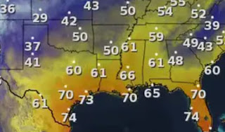
Those watches may be extended to include the South Shore too with coastal Mississippi later tonight. This Severe risk is due to a powerful upper trough diving into central Texas. We are in the warm air sector with temps in the 70s.
From what I'm seeing, this will be a widespread outbreak of severe storms covering many states, There are two areas of strong storms affecting SE LA/MS this morning.
All of the radar images are from 10:45 AM. Use your FOX 8 Weather App to keep up with the latest radar views. For now, I believe the worst/highest severe threat arrives towards dark and continues through midnight. A weak surface front will bring slightly cooler, but much drier air here for Sunday & Monday.
With temps 75-80, dew points 70+ and shifting winds with height, it appears all the ingredients are there for nasty storms marching from Texas across Louisiana. It is a Pay Attention Day.
Our next real cool down won't arrive until late Tuesday night. There could be some dense fog around for the fireworks. It's back to sweaters & jackets late week, but the Arctic air should stay well to our north. If you're traveling around this afternoon & evening, track those storms on radar so you're not surprised. There could be some brief street flooding to go along with the severe threat too. Stay tuned!


.jpg)
No comments:
Post a Comment