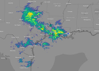
Often times it's the upper air flow that dictates what happens down at the surface. During the Winter months, the dreaded Southwest upper flow typically means over ru8nning warmer air produces lots of clouds and a cold rain. That set up begins with a split flow coming into the West Coast with the northern stream bringing an "atmospheric river" of moisture to Oregon & Washington. The southern stream is coming towards us.
The forecasting challenge is finding where the surface frontal boundary sets up that focuses the track for heavy rainfall. Both NWS & WPC graphics believe that track will be somewhere near SE LA / coastal MS. In the top two graphics, NWS places the heaviest rains to our west and over the North Shore.
In the bottom graphic, WPC has the focus slightly farther to the south. The red colors indicate 3-5"+ amounts.
Where the rain is falling to our west, temperatures fall into the 40s in a process called "evaporative cooling". That's where rain is falling into very dry air and evaporating. That is a cooling process, much like our bodies sweating in the summer to try to cool us down. Note the dew points in the teens, 20s & 30s.
We're likely to see several waves of showers/storms that might produce some brief street flooding. The next several days will be pay attention time until the next cold front blows through Tuesday night. Let's hope the Saints can make our Sunday happy? Who Dats 24, Giants 17. Stay tuned!


No comments:
Post a Comment