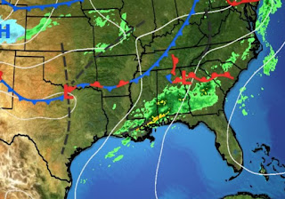
Several days ago, models were indicating the potential for a heavy rain episode somewhere along the northern Gulf coast. I described in my last post the forecast challenge due to the upper-level flow coming from the Southwest. This morning on FOX 8 News, Zack showed the heavy rain potential that was draped over the South Shore just south of NOLA. Reality turns out to have that boundary just to our west streaking to the NE across the North Shore. I give Zack credit for pointing out this swath of heaviest totals could be farther to the north or south and is just GUIDANCE. Models were correct on possible amounts, just slightly off on LOCATION.
So the forecasting challenge is to determine where will the next boundary set up? What is across the North Shore now is not coming south. The upper disturbance causing the storms is lifting away, but the SW upper flow remains.
At 3 PM, satellite & radar views do not show a new boundary developing off our coast to the SW. However, watching several noon weather programs, models are hinting there will be new boundaries developing over night into late Tuesday. That is why NWS has all of SE LA/MS under a Flood Watch. What I'm seeing is new boundaries forming farther to our west and north.
That should mean the heaviest rains will stay north of Lake Pontchartrain for this afternoon and over night. Tuesday may see the boundaries shifting our way as a deeper upper trough comes out of the Rockies. That, coupled with deep low-level moisture out of the Gulf could mean a greater severe potential on Tuesday.
Right now, SPC has us in a level one risk (Marginal) for strong storms overnight into Tuesday. My gut tells me they will increase that IF all the ingredients (moisture, warmth, upper disturbance) come together for later on Tuesday. We still need to pay attention tomorrow until the cold air arrives for Wednesday.
From the surface map, you can clearly see our current heavy rains are not caused by a cold front. Look at the warmth back in the sunshine at San Antonio (83). Couple the warmth with high dew points (65-70) and you can understand why I'm a little nervous about the strength of tomorrow's storms. FOX 8 is not crying wolf by keeping their First Alert up through Tuesday night, especially if we break out into some sunshine and see temps soar to 75-80.
The heavy rain boundary is not that far from the South Shore. We could get clipped during the next several hours, but I have not changed my evening dinner plans. Those of you to the west and north need to pay closer attention in case the current boundary doesn't move. Wednesday's cold front looks to be about as strong as the last one, which should mean any freezing temps stay to our north. All my plants are back outside. Stay tuned!


No comments:
Post a Comment