Today's model guidance really hasn't changed from previous thinking and I still believe a moderate freeze (24-28) is coming to the North Shore with, at worst, a light freeze (29-34) south of Lake Pontchartrain. I spent the morning on my ladder picking 24 grapefruit still on my tree. I couldn't get the last 12 since I was getting nervous being so high up the ladder. (77 and climbing a ladder?!!!) I figured they'll have to just fall off since the tree is 18 years old and 20 feet tall.
The Jesuit birdhouse is 15 feet off the ground and the tree is way taller than that. I moved most of my tropical plants into my He-Shed and will finish that process tomorrow. December was so mild (no freezes) that many of my flowers still look great.
But alas, the cold is coming and the question now is "How Cold will it get". As I've mentioned in previous posts, the "Polar Vortex" is NOT coming south and that will keep the core of the cold well to our north & east. However, this is a large Arctic high coming into the lower 48 and its mass & momentum will surge it down into the Gulf. I'd be worried about lower temperatures coming IF we had nearby snow cover. We don't as the current snow cover is far to our north.
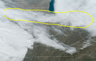
I've circled in yellow the current snow cover viewed on satellite.(you can see the rivers) The rest of the white are clouds from the next storm that will lay down more snow farther south of the current area. Still, that is not like Oklahoma or Arkansas has a snow cover. With sunshine & daytime heating, that should allow our highs to approach 50 this coming week.
From what I'm seeing, the storm towards the end of the week might take a track farther to the south. Models have backed off on any frozen precip. here, but Arctic air often is very difficult to move out. I still think there might be some frozen(sleet/ice pellets) stuff over the North Shore, but since models don't show that, all weathercasters will go with too warm for snow. Snow geeks, don't give up yet.
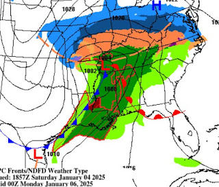
There is a potent upper system coming out of the Rockies that will deposit snow & ice for many tomorrow and Monday. I grabbed these graphics off The Weather Channel.
This could be a severe ice storm from Kansas City to Louisville. For us, a cold front coming after dark on Sunday will bring some strong storms. SPC has us in a level 2 (slight) risk with the level 3 (enhanced) risk being farther to the north. It will not be an all day event here as the storms should be with the front.
The front at 6 PM will be nearing Lake Charles arriving here around midnight. The greatest threat for severe storms here will be between 7-10 PM.
There is quite a temperature contrast between north & south. Let the battle begin!
Despite all the clouds, only some light sprinkles are falling around us. You still have tomorrow to get your yard ready as highs will be 75-80. I have my faucet covers on & my water hose drained just in case. After the Saints finish their season tomorrow, (Bucs 31, Saints 10), go get those tender plants protected. Right now, I'm not doing anything for my in ground stuff. We'll look at it again tomorrow. Stay tuned!


No comments:
Post a Comment